Recording War Damage (DFG)

Content and objectives
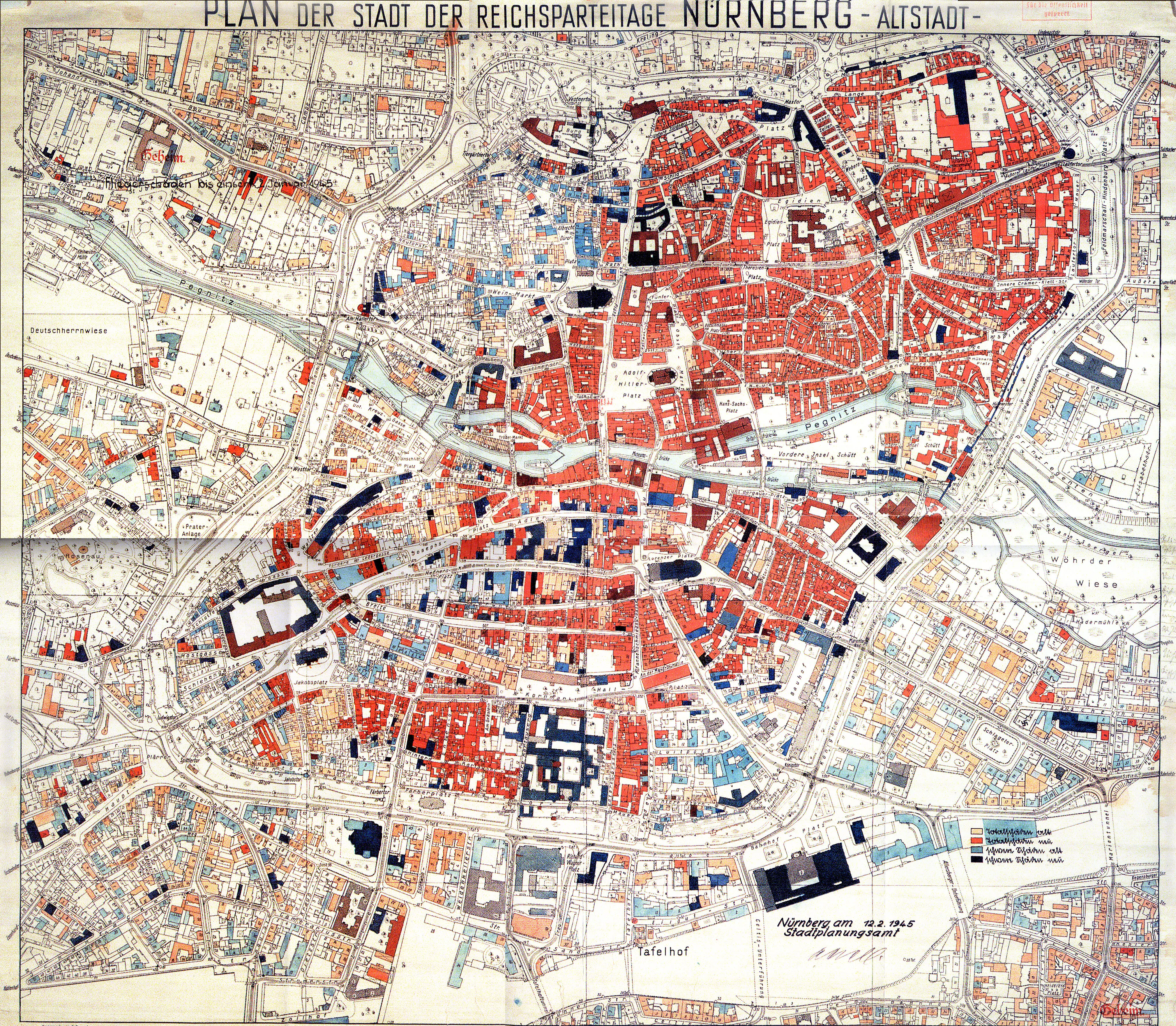
Most cities affected by the Second World War kept records of war damage and produced damage maps. These little-studied documents are valuable historical sources because they contain information about urban history, heritage conservation and cultural geography. On the basis of war damage maps, municipalities decided the future of rubble sites and ruins. At the same time, local actors reappraised their built cultural heritage and drew up new inventories of historically significant buildings.
The project “War Damage Recording in the Second World War as a Heritage-Making Moment” (DFG) gathers together the archival records in which war damage is listed and evaluated, with a specific focus on eight cities in Central Europe. The project is comparative in nature and international in scope, and is being conducted in close cooperation with the Department of Heritage Conservation at Carleton University in Ottawa, Canada. The aim is a systematic collection of damage maps in digital form, which will be indexed and made accessible for academic research. The platform wardamageatlas.com will publish these data.
Research design
The municipal archives in the cities unter study contain maps and lists that record war damage or building assessments, but these are often held in separate archival collections. These documents are to be systematically researched and linked, which will aid in recovering missing map legends and thus make it possible to read the entire content of each map. In addition to local map inventories, there is also a total inventory of damage maps for cities within the sphere of influence of the German Reich: during the war, the “German Taskforce for the Reconstruction of Bomb Damaged Cities” collected damage maps from the Reich Minister for Armaments and War Production. This inventory is used as a reference collection (private collection of Niels Gutschow: Carleton University Archives and Staatsarchiv Hamburg).
Initial findings
Soon after the project began, it became clear that the damage maps prepared for German cities were more varied than was previously realized. Their functions ranged from the preparation of compensation payments to use as a planning basis for urban development, and from the presentation of monument values to the organisation of rubble clearance in individual properties. Frequently, the maps contained 3D information that indicated the number of intact floors in a damaged building. When published, such maps were often simplified, thus they contained radically reduced information.
Utilization of findings
The study of damage maps makes it possible to read the rebuilding process less as a simple reaction to destruction, and more as the result of deliberate and calculated decision-making on the part of the wartime and post-war generations. It allows for a more nuanced view of the post-war city and provides a basis -- lacking thus far -- for a critical analysis and appreciation of this rebuilding era.
In the age of satellite and drone images, a comparative typology and critique of existing damage maps promises to provide those dealing with present-day catastrophes with models for the production of their own such maps, and for the decision-making processes that rely on them.
Further information
• Carleton University, Ottawa (Canada):Prof. Jerzy Elżanowski
• Centre for Historical Research in Berlin, Polish Academy of Sciences (CBH)
Research-led teaching
• Seminar „Ruinen und urbanes Kulturerbe: Stadtkartierung in Nürnberg 1940-1950“ ("Ruins and urban cultural heritage: city mapping in Nurember, 1940-1950") – Instructor: Dr.Ing. Carmen M. Enss – Winter semester 2019/20
Conferences
Symposium: Erbe in Trümmern. Schadensbild, Transformation und Heritage Making in kriegszerstörten Städten um 1945, May 20, 2021, 9:00-13:00, via Zoom.
Books
Enss, Carmen M. / Knauer, Birgit (Hg.): Atlas Kriegsschadenskarten Deutschland, to be published in December 2022 by Birkhäuser.
Enss, Carmen M. / Sedlmeyer, Georg-Felix (Hg.): Ruinen und Urbanes Kulturerbe. Stadtkartierung in Nürnberg 1942 – 1952. Ergebnisse aus dem Profilierungsseminar des Masterstudiengangs Heritage Conservation, Otto-Friedrich-Universität Bamberg 2020 (DOI: https://doi.org/10.20378/irb-47932).
Articles
Sedlmeyer, Georg-Felix: Sperrzone Heimat. Bausperren für den Wiederaufbau am Ende des Zweiten Weltkriegs, in: Blokker, Johanna / Enss, Carmen M. / Herold, Stefanie (Hg.): Politiken des Erbens in urbanen Räumen, Bielefeld 2021, S. 179–190.
Enss, Carmen M. / Stein, Klaus / Sedlmeyer, Georg-Felix: Organizing disaster: Interpretating and categorizing thematic maps of war-damaged cities from the 1940s, Spatial Humanities 2022 (DOI: https://doi.org/10.5281/zenodo.6810998).
Sedlmeyer, Georg-Felix: Das Dölitzer Schlösschen–Geschichte und Narrativ, in: Habeck, Otto J. / Schmitz, Frank (Hg.): Sammelband zur Ringvorlesung „Ruinen und vergessene Orte“, Universität Hamburg, to be pubslished in 2023 by transcript.