Research Projects
The Laboratory for Semantic Information Technology is part of the Chair for Computing in the Cultural Sciences.
Geogames
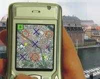
The Geogames project aims at the development of innovative game concepts for location-based games. Location-based games are played on mobile devices using positioning technology (like GPS) and integrate the players’ position and motion track into the rules of the game.
Geogames are created by a specific mapping of existing board games into geographical space. They combine the strategic aspect of the board games with the locomotion typical for sportive activities through a spatio-temporal synchronization mechanism specifically designed for that purpose.
Besides the entertainment aspect of how to create a challenging game, the Geogames project also addresses issues of mobile edutainment, game AI for location-based games, context-aware information push, and user interface design.
Contact person: Prof. Dr. Christoph Schliederhttp://www.uni-bamberg.de/?id=11072
The research project "Digitales Dombauarchiv" (only in German), which is funded by the DBU, aims at developing new methods and concepts for archiving and documentation as basis for the monitoring of environmentally related damage on historic buildings.
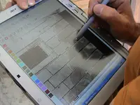
Within the sub-project "Mobile Mapping System" the Laboratory for Semantic Information Technology designs and realizes innovative software for mobile mapping of environmentally caused damage on historic buildings. With the help of mobile devices like Tablet PCs MMS enables the preservation scientist to conduct the mapping of relevant data right at the physical monument.
Currently MMS is being extended in various small projects in cooperation with preservation scientists from e.g. Bamberg, Nürnberg, Augsburg, Passau and Vienna. Further more, a sub-project of the EU funded research project "Stonemarks" investigates appropriate tools and methods to convert old datasets (mappings) into the MMS standard.
Projectsite (At present only in German)
Contact person: Peter Wullinger, M.Sc.
FluPa-Guide
The FluPa-Guide project targets at the specific requirements of mobile assistance systems for biking tourists. Unlike a pedestrian tourist, bikers are much more restricted in the possibilities to interact with a mobile device. This leads to the necessity to predict a tourist’s information needs from the available contextual information.
In the context of this project, the Geogames team is developing a location-based tourist guide running on Pocket PC for our project partner Flussparadies Franken e.V.. The guide will be available from summer 2007 and cover the biking trail along the river Regnitz from Bamberg to Erlangen.
As a second objective, the FluPa-Guide project aims at developing an innovative game concept for a location-based game that can be played along a linear geographic object (like a river). The resulting Geogame will be integrated as an optional component into the tourist guide.
Projectsite
Contact person: Prof. Dr. Christoph Schlieder
Tripartite Multimedia Object Description "TriPod"
Tripod´s primary objective is to revolutionise access to the enormous body of visual media. Applying an innovative multidisciplinary approach Tripod will utilise largely untapped but vast, accurate and regularly updated sources of semantic information to create ground breaking intuitive search services, enabling users to effortlessly and accurately gain access to the image they seek from this ever expanding resource.
Any image tagged with a direction and location can be harnessed, either legacy photographs with place name captions (therefore all old photos are maintained) or those produced by increasingly prevalent cameras with build in compass and GPS information (thereby managing the future). Tripod will augment images with spatial data to compute contextual information about the location and features of the actual landscape pictured. Using 3D models, building and landscape features contained in the image will be identified and located within the picture. Methods from a number of disciplines will use the spatial data to derive additional semantic information about the area photographed. Techniques from Web search and text summarisation will be applied to automatically create textual descriptions of the photographs, producing a rich readable and multifaceted caption far removed from merely location but encompassing culturally encoded notions such as beauty and socially connoted language of place such as suburb, west end, etc.
Like Google, Tripod is domain independent. Its services can be applied to broad range of searching needs and languages due to the adaptability and flexibility of the caption generation. It is a solution for the exponential swell of images available as it will manage all images with a location and potentially video as well. Tripod will empower the user by adapting the search infrastructure to the future by bridging the semantic gap.
Projectsite
Contact person: Prof. Dr. Christoph Schlieder
Data Mining System
Analysis of Field Data in the Automotive Industry
Joint Research Project with DaimlerChrysler
Group Research / Quality Analysis
In this joint research project we aim at developing new and integrated methods and processes to improve field data analysis at DaimlerChrysler. Based on existing applications and prototypes at Chrysler Group, Mercedes Car Group and the Truck Division we evaluate, develop and implement processes and applications for Early Warning, Root Cause Analysis, Diagnosis and Knowledge Extraction from Field Data. We apply and enhance selected methods from Statistics, Knowledge Discovery in Databases (Data Mining) and Semantic Information Technology.
Contact person: Prof. Dr. Christoph Schlieder
COM
The COM (Communication-Oriented Modelling) project is part of the DFG priority program "Sozionik" and is a cooperation between the institute of technology and society at the University of Technology Hamburg and the Chair of Computing in the Cultural Sciences at the Univiersity of Bamberg.
While normally communication is described as a sender passing
messages to a receiver and vice versa, in mass communication messages are published to an (unknown) readership, referring other messages published before.
COM aims to examine and to simulate large scale communication processes, from scientific paper networks to usenet newsgroups and the world wide web.
Projektsite
Contact person: Dr. Klaus Stein
Cost Action G9 "Modelling Real Property Transactions"
The COST (Co-ordination in the field of Scientific and Technical Research) Action G9 "Modelling Real Property Transactions" coordinates European research in the cadastral domain. Several European countries develop conceptual models of their cadastral systems and process models of real property transaction. In addition to the national cadastral models, common reference models are designed which reflect concepts known in most or even all European cadastral systems These models improve the transparency of real property markets and permit to compare the costs of property transactions in the European Union.
Projectsite
Contact person: Prof. Dr. Christoph Schlieder
TeDUB
The project TeDUB (Technical Drawings Understanding for the Blind) is part of the Information Society Technologies (IST) program, funded by the Eureopean Union.
The objective of TeDUB is to develop a software that allows blind users to read technical diagrams.
Projectsite
Contact person: Prof. Dr. Christoph Schlieder

